
Please enable Javascript to watch this video
NEW YORK — A blizzard watch has been issued for New York City, Long Island and portions of coastal northeast New Jersey as the region braces for a potentially historic snowstorm that could dump as much as a foot of powder on the five boroughs and portions of Long Island and New Jersey, according to the National Weather Service.
The alert goes into effect Saturday morning and is set to last through Sunday afternoon.
A blizzard watch means there is potential for falling snow and strong winds, causing poor visibility conditions. Travel can be dangerous during the time that watch is in effect.
While New York and New Jersey are under the watches, Connecticut has no storm or blizzard watches as of Thursday morning, the NWS said.
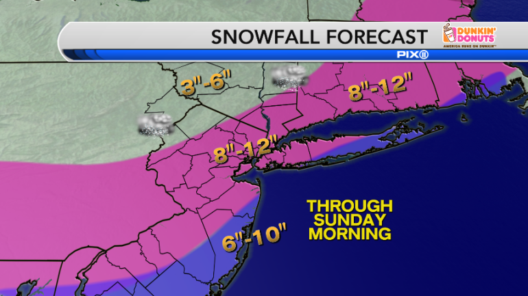
Snowfall forecast as of Thursday morning, Jan. 21, 2016. (Photo: PIX11 Weather Center)
Snowfall is expected to begin Saturday morning and become heavy at times through the afternoon. Rain and sleet may mix with snow over the coastal areas Saturday afternoon.
Total snow accumulations are forecast to be 8 to 12 inches in New York City, western Long Island, central and western New Jersey, and coastal Connecticut; 6 to 10 inches for eastern Long Island and coastal New Jersey; 3 to 6 inches north and west of the city.
Eventually the storm will taper off late Saturday night into Sunday morning and the sun will begin to peak out by the afternoon.
Snow isn’t the only worry this weekend.
With the full moon taking place, high tides naturally will be higher than normal. Add in the nor’easter and there will be problems along the coast. Wind gusts as strong as 50 mph could push water along the shoreline, bringing a storm surge of 2 to 3 ½ feet. That may bring moderate coastal flooding during the two high cycles of Saturday.